Delhi Rain

Delhi: No Significant Rainfall Likely During next 2-3 Hrs

Latest radar imagery shows no significant rainfall likely over Delhi and the neighbourhood during the next 2-3 hours, informed the India Meteorological Department (IMD).

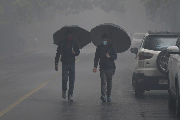
The city will receive moderate rainfall accompanied by thunderstorms and will have cloudy skies today, as per the weather forecast,
Meanwhile, the Delhi government on Sunday issued a flood warning amid heavy rains in North India, as the Haryana government released more than one lakh cusecs of water into the Yamuna River from the HathniKund Barrage in Yamunanagar.

The water level in the Yamuna River in Delhi is rising and is expected to breach the danger mark of 205.33 metres on Tuesday, the Central Water Commission (CWC) said on Sunday.

In view of incessant rains in the national capital, Union Home Minister Amit Shah on Sunday spoke to Delhi Lieutenant Governor Vinai Kumar Saxena and took updates.

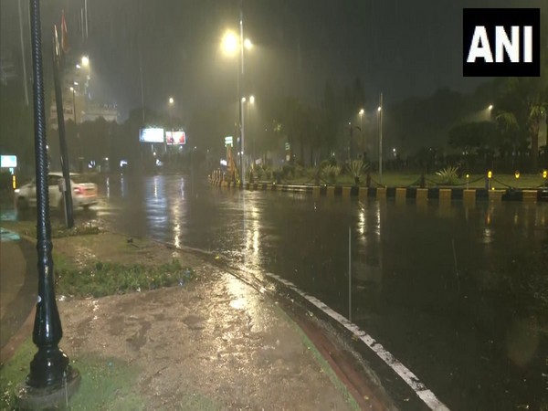
Pictures and videos of commuters wading through knee-deep water flooded social media platforms, raising concerns over the efficiency of the city’s drainage infrastructure.

Delhi Traffic Police kept tweeting updates on how the vehicular movement was being impacted because of the downpour. They also shared images of waterlogged areas.

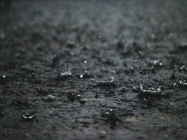
The national capital recorded 153 mm of rainfall in 24 hours ending at 8:30 am on Sunday, the highest in a single day in July since 1982, the India Meteorological Department (IMD) said.

Several parts of northwest India witnessed a heavy spell of rain with Delhi shattering a 41-year record on Sunday. There were reports of house collapses, uprooting of trees and waterlogging in several residential colonies. Waterlogging issues were also observed in diplomatic enclaves such as Chanakyapuri, Kaka Nagar, Bharti Nagar, and other prominent roads and colonies under the jurisdiction of the NDMC.

Further, according to the IMD, an interaction between a western disturbance and monsoonal winds is leading to an intense rainfall spell over northwest India, including Delhi, which experienced the season’s first “very heavy” rainfall. (ANI)

Read More: http://13.232.95.176/

IMD yellow Alert

IMD Yellow Alert For 18 Districts Of Odisha From July 3-7

The India Meteorological Department (IMD) in Bhubaneswar, Odisha, has issued a yellow warning for 18 districts of Odisha from July 3 to 7.

According to the IMD forecast, light to moderate rain or thundershowers are very likely to occur in a few places in the districts of Odisha.
“Thunderstorm with lightning very likely to occur at one or two places over the districts of Balasore, Bhadrak, Jajpur, Kendrapara, Cuttack, Jagatsinghpur, Puri, Khurda, Mayurbhanj, Keonjhar, Dhenkanal, Gajapati, Ganjam, Rayagada, Koraput, Malkangiri, Nayagarh, Angul.” IMD prediction for July 3 from 8:30 am.

For July 3 from 8:30 am to 8:30 am of July 4, IMD predicts “thunderstorm with lightning very likely to occur at one or two places over the districts of Balasore, Bhadrak, Jajpur, Kendrapara, Cuttack, Jagatsinghpur, Puri, Khurda, Nayagarh, Ganjam, Gajapati, Mayurbhanj, Keonjhar, Dhenkanal, Angul, Boudh. Heavy Rainfall very likely to occur at one or two places over the districts of Gajapati, Ganjam, Rayagada, Koraput, Malkangiri, Kandhamal, Nawarangapur.”

On July 4, from 8:30 am to 8:30 am of July 5, the IMD predicts a “thunderstorm with lightning very likely to occur at one or two places over the districts of Sundargarh, Jharsuguda, Bargarh, Sambalpur, Deogarh, Angul, Dhenkanal, Keonjhar, Mayurbhanj, Sonepur, Boudh, Bolangir. Heavy Rainfall very likely to occur at one or two places over the districts of Nuapada, Nawarangapur, Kalahandi, Kandhamal, Ganjam, Gajapati, Malkangiri, Koraput, Rayagada.”

From July 5, 8:30 am to 8:30 am on July 6, IMD forecast Heavy Rainfall very likely to occur at one or two places over the districts of Puri, Khurda, Nayagarh, Ganjam, Gajapati,Boudh, Bolangir, Nuapada, Kalahandi, Kandhamal, Nawarangapur, Rayagada, Malkangiri, Koraput, Cuttack.

From July 6, 8:30 am to 8:30 am on July 7, IMD forecasted “Heavy Rainfall very likely to occur at one or two places over the districts of Koraput, Rayagada, Nawarangapur, Kalahandi, Nuapada, Bolangir.

The India Meteorological Department (IMD) on Sunday informed that Tamil Nadu will likely receive light to moderate rainfall in several districts in the next 4 days.

According to the IMD, a gyre zonal circulation prevails over the Southwest Bay of Bengal and also due to the variation in speed of the westerly wind Tamil Nadu will experience light to moderate rainfall at many places in the coming days.

“On July 3, light to moderate rain with thunder and lightning at many places over Tamil Nadu, Puducherry and Karaikal. Heavy to very heavy rainfall at one or two places in Nilgiris and Coimbatore districts, Tirupur, Dindigul, Theni, Thenkasi, Tirunelveli, Kanyakumari, Tiruvallur, Chennai, Kanchipuram, Chengalpattu, Vellore, Ranippet, Tirupattur, Thiruvannamalai, Villupuram, Cuddalore and Puducherry districts”, the IMD said in a statement.

The statement further said that light to moderate rain with thunder and lightning at a few places over Tamil Nadu, Puducherry and Karaikal on July 4.

Light rainfall has been predicted in the Delhi-National Capital Region over the next two-three days, followed by light to moderate rains for the next three days, as per India Meteorological Department. (ANI)

Read More: http://13.232.95.176/

heatwave India in 23 years

Third-Highest Heatwave Conditions In Last 23 Yrs This Summer: IMD

India, this year, experienced the third-highest instances of heatwave and severe heatwave conditions in the last 23 years, after 2019 and 2022, the India Meteorological Department (IMD) has said.

The Met agency said heatwave and severe heatwave conditions this summer were the third-highest after 578 MSD (mean standard deviation) in 2019 and 455 MSD in 2022.
Further, according to the IMD, above-normal heatwave days were observed in the country’s eastern parts, including West Bengal, Odisha, coastal Andhra Pradesh, Bihar, Jharkhand, Chhattisgarh, and the adjoining central parts including eastern Madhya Pradesh, Vidarbha and Telangana.

Apart from this, heavy rainfall activity occurred in three to four zones in the month of June, including Assam, south Uttar Pradesh, Himachal Pradesh and Uttarakhand, the IMD said, adding that Gujarat also experienced heavy rainfall but that was largely on account of severe cyclonic storm ‘Biparjoy’.

Meanwhile, the IMD on Friday said Mumbai, Thane and Palghar in Maharashtra are expected to receive moderate to intense spells of rainfall over the next 3-4 hours.

Earlier, an official statement from the IMD stated, “Due to active monsoon conditions enhanced rainfall activity with heavy to very heavy rainfall is expected at a few places over parts of Konkan and adjoining ghat areas of Madhya Maharashtra during the next 2-3 days.”

Heavy rainfall in the Panna district of Madhya Pradesh over the last three days hit road connectivity while throwing traffic out of gear. Heavy waterlogging was also reported at several government offices, including that of the Home Guard and the Department of Horticulture and Food Processing.

A boat was spotted sailing at a government office after rainwater entered the premises in the Panna district of MP on Thursday.

Meanwhile, parts of the national capital and adjoining areas experienced sharp showers in the wee hours of Friday, with extensive waterlogging reported in some areas.

The IMD forecast more moderate to heavy rainfall in parts of Delhi, UP, Rajasthan and Madhya Pradesh in the next couple of days.

Earlier, on Thursday, heavy rain lashed several isolated areas of Delhi-NCR, bringing down the minimum temperature to 27.1 degrees Celsius. (ANI)

Read More: http://13.232.95.176/

Yellow alert in Kerala

Monsoon 2023: Yellow Alert in Eight Districts Of Kerala

The India Meteorological Department (IMD) forecast widespread rain in Kerala on Friday and issued a yellow alert for eight districts in the state.

With Cyclone Biparjoy forecast to be intensified in the next 36 hours, the weather department has also advised fishermen not to venture into the seas off the coast of Kerala, Karnataka, and Lakshadweep.

The districts in Kerala where the yellow alert is issued on Friday are Thiruvananthapuram, Kollam, Pathanamthitta, Alappuzha, Kottayam, Idukki, Kozhikode, and Kannur.

The monsoon will advance to the remaining parts of Kerala, some parts of Tamil Nadu, Karnataka, and the Northeast in the next 48 hours, said India Meteorological Department (IMD) on Thursday.

The Southwest Monsoon hit India on Thursday with its onset over Kerala, a week after the normal date of June 1, said IMD.

Cyclone Biparjoy is set to intensify in the next 36 hours and will be heading north-northwestwards in the next two days, the India Meteorological Department (IMD) said in a tweet on Friday. The weather department had also advised fishermen not to venture into the Arabian Sea. Those who were out at sea were advised to return to the coast, it had said earlier. (ANI)

Read More: http://13.232.95.176/

Drop In Mercury In Delhi-NCR

Drop-In Mercury By 2-3 Degrees In Delhi-NCR

After heavy rain on Sunday in many north Indian states, the weather department on Monday said that a mercury drop by two to three degrees Celsius is expected in Delhi-NCR.

The India Meteorological Department (IMD) recorded a minimum temperature of 10.2 degrees celsius on Monday in New Delhi. The maximum temperature is expected to reach 20 degrees celsius.
Naresh from the India Meteorological Department while talking to ANI said, “The effect of continuous snowfall in the hilly areas will be seen in the plains due to which there may be a temperature drop in the coming days.”

“No cold wave effect would be observed. There may be a drop in temperature by 2 to 3 degrees in the coming days including Delhi and NCR, due to which the cold may increase,” added the IMD representative Naresh.

“In areas like Jammu and Kashmir, Uttarakhand, and Himachal Pradesh, over 60-millimeter snowfall has been observed. While in states like Uttar Pradesh, Punjab, Haryana, and Delhi NCR, heavy to moderate rainfall was recorded,” added the IMD representative.

“In New Delhi specifically, 2-millimeter rain was recorded,” said Naresh.

The IMD official explained that the reason for the heavy rain on Sunday was western disturbances. He said, “Due to a strong western disturbance, moderate to heavy showers of rain over the northern half of the country was observed.”

Speaking of the rain, the IMD representative claimed that there are no chances of rain in Delhi-NCR on Monday. However, a drizzle can be seen in Punjab, Haryana, and Himachal Pradesh. (ANI)

Read more: http://13.232.95.176/

Dense fog Delhi

Delhi Experienced Third Worst Cold Spell In 23 Years: IMD

India Meteorological Department (IMD) on Tuesday said that Delhi experienced the third worst cold spell in the last 23 years and also gave a second cold spell warning from January 14.

Talking to ANI, RK Jenamani, Scientist, IMD said that Delhi experienced a cold wave right from January 3-9 which is almost 5 days.
“During these five days, the temperature was around two to four degrees. As per the data available with us, this was the third worst cold spell in 23 years. From the year 2000 to the year 2023, we find that the 3-9 Jan cold spell was the third worst cold spell in the last 23 years,” he said.

A cold spell means the number of days we experienced which is in the range of 5 to 6 days. A similar situation was there in the year 2006 when we had the lowest temperature of 1.9 degrees Celsius. In 2013 also, we had a similar cold spell, and January 3-9 was the third worst cold spell in the last 23 years.

IMD has also predicted rain, drizzle, and snowfall on January 12, and a second spell of cold spell on January 14.

Jenamani said that there will be light rain or drizzle in states like Punjab, Haryana, Chandigarh, Delhi, Western UP, and North Rajasthan.

“For the Himalayan states like Jammu and Kashmir mainly Kashmir, we expect heavy rain or snow on Jan 12. We expect rain or snowfall in Himachal and Uttarakhand between January 11-14,” he said.

He said that we are also giving a second cold spell warning from January 14th.

“There will be fresh cold spells over northwestern and Punjab. We have not confirmed but we are reviewing whether the daily temperature will further come down to three degrees or not. Western Disturbance is very active and there are chances that there might be a cold spell from Jan 14,” he said.

Jenamani further said that there will be clouding and fresh moisture pertaining to the Western disturbance.

“The Western disturbance is expected to hit over the western Himalayan region and also plane area during 11 to 14th Jan. It will lead to clouding and fresh moisture also. Because of the windy condition, the dense fog condition will improve further. There was dense fog at the Delhi airport in the past 24 hours. But in the main city, it was relatively lesser fog,” he said.

He further said that although the condition is improving, the worst condition persists over Bihar and Uttar Pradesh.

“So far, the condition is improving, but Bihar and Uttar Pradesh remain in the worst condition,” he said. (ANI)

Read more: http://13.232.95.176/

Severe Cold Wave Conditions Persist In Delhi

Dense fog and cold wave conditions continued to sweep the national capital with the city recording a minimum temperature of 7.8 degrees Celsius on Wednesday morning.

According to the India Meteorological Department (IMD), cold day conditions are likely to abate over northwest India from Wednesday and then resurge from December 31.
According to RK Jenamani, fresh cold wave conditions shall prevail again from December 31 to January 1, 2023.

“Dense to very dense fog will continue to prevail in the belt. There will be an improvement on Dec 29 because of a western disturbance that will bring fresh snowfall in Jammu and Kashmir, Leh, and Himachal Pradesh. There will be drizzle in north Punjab on Dec 29,” he added,

From Dec 28 onwards there will be a significant improvement as the cold wave will go due to western disturbance, stated Jenamani. In Delhi so far, the lowest temp of 4.0 degrees celsius was recorded at Aya Nagar and a cold wave is still prevailing at isolated places.

Amid a cold wave prevailing in parts of northern India, Palam in Delhi recorded a minimum temperature of 7.8 degrees Celsius while Safdarjung recorded a minimum temperature of 8.4 degrees Celsius on Wednesday.

The IMD has predicted that the minimum temperature in the national capital is expected to remain around 7 degrees Celsius throughout the day.

The national capital reeled under a cold wave and foggy conditions, disrupting normal life. A layer of dense fog was observed in the national capital region, reducing the visibility and the speeds of vehicles across the area.

The visibility at Palam was recorded at 500 meters.

Visibility remained low in Punjab, with Amritsar recording visibility of up to 25 meters and Patiala 200. While Bhatinda recorded zero visibility once more.

Haryana too recorded low visibility. While Ambala recorded a low of 200, visibility in Chandigarh was also 200 meters.

Uttar Pradesh’s Bareilly recorded 25m and Bahraich recorded 200m. Bihar’s Purnea and Odisha’s Gopalpur recorded a low of 50m each.

Earlier on Tuesday, IMD predicted “dense to very dense fog very likely to continue over many parts of Haryana, Chandigarh, and Delhi”.

“Due to prevailing light wind and high moisture in lower tropospheric levels, dense to very dense fog are very likely to continue over many parts of Haryana, Chandigarh and Delhi, West Uttar Pradesh, and in isolated pockets over north Rajasthan during the next 24 hours. Its intensity and spread are likely to reduce thereafter,” the IMD said.

Dense fog is very likely over Arunachal Pradesh, Assam and Meghalaya and Nagaland, Manipur, Mizoram, and Tripura during the next three days, according to IMD.

Meanwhile, cold day and severe cold day is mainly over south Haryana and West Uttar Pradesh. Day temperatures improved over north Punjab, north Haryana and North Rajasthan. Cold to severe cold waves continue over Punjab, Haryana, North Rajasthan, and Delhi said scientist RK Jenamani, IMD. (ANI)

Read more: http://13.232.95.176/